Honda Scoopy FI for rent in Ubud, Bali Honda Vario Techno 125 for rent in Ubud, Bali Honda Vario eSP 150 for rent in Ubud, Bali Honda PCX 150 for rent in Ubud, Bali

Tulamben

The town's name is derived from the word batulambih, which roughly translates as "many stones" a reference to the destructive eruptions by Mount Agung that have effected this part of Bali from time to time. The beach in Tulamben is not made of sand, but entirely covered with fairly large, smooth stones. The modern name evolved over time, first to "Batulamben" and finally settling on the contraction Tulamben ("batu" means "stone" in Indonesian)


Fish in Tulamben
Fish

Tulamben Beach
Tulamben Beach

Tulamben Under Sea
Diving in Tulamben

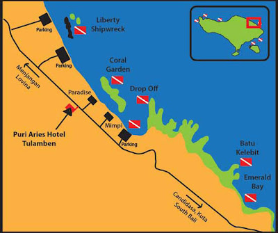
Tulamben is a small fishing village on the north-east coast of Bali. It is among the most popular dive sites on Bali since the wreck of the Liberty, a US Army Transport ship torpedoed by a Japanese submarine in 1942 lies just off shore. During high-season, up to 100 divers descend to the wreck each day


Tulamben Map
Tulamben Map

Taman Ujung

Taman Ujung to the southeast of Karangasem (Amlapura) is another water palace built by the predecessor of the King who constructed Tirta Gangga. It must be said that it is rather inferior, but still a charming attraction and worth a visit. 

Taman Ujung was built in 1909 as a relaxation and recreation palace by the then King of Karangasem, I Gusti Bagus Jelantik. It was largely destroyed by the eruption of Mount Agung in 1963, damaged again by an earthquake in 1979, and has not been restored on the same scale as Tirta Gangga

You do get a sense of how lovely it must have been though. From Tirta Gangga, head back south to Karangasem and then take the minor road south east to the village of Ujung. Taman Ujung is another 2 km past the village, very close to the coast. If you are staying in Tirta Gangga or Candidasa, you will certainly be offered tours which include Taman Ujung.

Taman Ujung
Taman Ujung

Taman Ujung
Taman Ujung

Taman Ujung
Taman Ujung

Tirta Gangga

Tirta Gangga literally means water from the Ganges and it is a site of some reverance for the Hindu Balinese. Strictly, the name refers to the water palace built here in 1946 by the King of Karangasem. 

It is though widely used to refer to the general area which includes the water palace and some particularly stunning rural areas around. Tirta Gangga is a popular side trip from the nearby coastal resort towns of Amed and Candidasa. Organised tours are widely offered. 

Public buses run from nearby Karangasem town and Perama buses can be chartered from Candidasa. If you are driving yourself, Tirta Gangga is on the main east coast road just north of the town of Karangasem (Amlapura) and is fairly well signposted.

Tirta Gangga
Tirta Gangga

Tirta Gangga
Tirta Gangga

Tirta Gangga
Tirta Gangga
The primary draw in this area for visitors is the Tirta Gangga water palace, a lovely maze of pools and fountains surround by a lush garden and stone carvings and statues. The one hectare complex was built in 1946 by the late King of Karangsem but was destroyed almost entirely by the eruption of nearby Mount Agung in 1963. It has been lovingly re-built and restored and has an air of authentic royal magnificence. The centrepiece of the palace is an eleven tiered fountain, and there are many beautiful carvings and statues adorning the gardens. This is a great spot to unwind and it has a real atmosphere of old Bali. The area around Tirta Gangga holds some stunning rice paddy terraces. Those postcard pictures of Bali rice terraces which you have all seen are usually from photographs taken here.

North of Tirta gangga rice terrace
Rice paddies north of Tirta Gangga

Padang Bai

Most visitors to Padang Bai are there to catch a boat to Lombok and Gili Islands. It is though a charming little place in its own right and many people cancel their trip in order to spend more time in this lovely village. Spending a night or two here will certainly not be time wasted.  

There is good diving and snorkeling in the immediate area, and a number of operators are present to cater for those activities. 

This is also a fairly convenient base from which to explore some of the wider attractions of East Bali. Accommodation tends to be quite basic and aimed at the backpacker market.

Padang Bai Boat
Padang Bai Beach


Padang Bai Beach
Padang Bai Beach

Padang Bai Map
Padang Bai Map

Amed

Amed refers to a long stretch of coast running from the village of Cucik about 14 km eastwards incorporating the seven villages of Amed, Jemeluk, Bunutan, Lipah, Selang, Banyuning and Aas. The pace of life here is slow and the coastal scenery quite stunning making Amed the perfect place for a relaxed holiday in Bali.

Amed is the most recent tourist development area in Bali. It was only in 2000 that tarmac was laid on the roads. Telephone lines were installed in 2003 and it took until 2007 for a bridge to be built over a section of the main road that regularly washed away during the rainy season.

This is the most commonly used base for visitors wishing to dive the USS Liberty wreck at Tulamben and that area is also covered by this article. There are other good dive sites close at hand and a thriving dive industry has developed all the way along the coast here.
Amed's inhabitants live from fishing, salt-making and tourism. The lack of tourism-based revenue, its remote nature and the generally harsh environment for farming, meant that this area was very much one of the poorer areas in Bali. Amongst others, the East Bali Poverty Project drew attention to the plight of the local villagers in this area and that, together with recent tourist development, has gone a long way to improving general standards of living, health and education.


Sunset in Amed
Amed Beach During Sunset
.
Amed Map
Amed Map

Amed Beach Black Sand
Amed Black Sand

Amed View
Amed View


Tenganan

Tenganan is a Bali Aga or original Balinese village. Protected for centuries from the outside world by surrounding walls, the ancient village has maintained its pre-Hindu customs through a strong code of non-fraternization with outsiders. 

Unique rituals and practices are preserved, and girls as young as two are wrapped in silk and donned with multi-colored scarves and flowered crowns of beaten gold during festivals. The village women weave the famous 'flaming' cloth, kamben gerinsing, which is purported to have the power to immunize the wearer against evil. 

A single cloth can take five years to complete and a large piece can cost well over a thousand dollars. The Fight of the Pandanus Leaves takes place annually during the Usaba Sambah festival. Two men would fight like gladiators, armed with only a round, plaited shield while attacking each other's bare bodies with bunches of thorny pandanus leaves. After the battles, the wounds are treated with a mixture of turmeric and vinegar, thus leaving no scars.

Tenganan Village
Tenganan Village

Tenganan Village
Tenganan Village

Perang Pandan
Perang Pandan

Gerinsing Tenganan
Gerinsing

Candidasa

The stretch of coastline from Manggis through Candidasa town itself and east to Bugbug, is normally just referred to as Candidasa. 

This is a laid back and very relaxing area of Bali with a wide range of accommodation options.

Many visitors, especially Europeans, combine a stay in the hotspots of south Bali with a more relaxed break here. The black sand beaches are very narrow and often disappear altogether at high tide.


Candidasa Beach
Candidasa Fishing Boat

Candidasa Beach
Candidasa Beach

Candidasa Beach
Candidasa Fisher Boat

Candidasa Map
Map of Candidasa

Besakih

Known as the 'Mother Temple of Bali', Pura Besakih is the biggest and holiest temple in Bali and is perched nearly 1,000m up the side of Gunung Agung. It is extremely enjoyable during festivals when the temple is decorated with colorful banners and the devotees come dressed in their finest, carrying meticulously arranged offerings. 

The destructive eruption of the volcanic Gunung Agung was said to be the wrath of the gods, having been offended by the Balinese who thought that the ceremony was supposed to be held every 100 years. 

The miscalculation by the priests had infuriated the gods and caused the destruction. Now, the festival is held more frequently instead of waiting for another century.

Besakih Temple
Besakih Temple

Besakih Temple Map
Besakih Temple Map

Besakih Temple
Basakih Temple
Besakih Temple
Besakih Temple

Goa Lawah

Located nine kilometers from Klungkung, Goa Lawah is a cave in which the walls vibrate with thousands of bats. These creatures' bodies are packed so tightly that the upper surface of the cave resembles undulating mud. 

A temple, which is believed to have been founded by a sage nine centuries ago, guards the entrance to this cave. 

This temple is said to extend all the way back to Pura Besakih and may continue to an underground river that comes up at Pura Goa, which is within the Besakih complex. Naga Basuki, the mythological gigantic snake, is believed to live in this cave.

Goa Lawah Temple
Goa Lawah Temple

Goa Lawah Temple
Goa Lawah Temple

Hanging Bats Goa Lawah
Hanging Bats

Klungkung

The former seat of the Javanese Hindu Kingdom in Bali, from where Balinese royalty draws its bloodline, Klungkung was the oldest kingdom on the island. 

The Kerta Gosa or Royal Court of Justice, which was built in the 18th century, is well known for its ceiling paintings in the traditional wayang style that portrays the pleasures and rewards in heaven as well as the punishments and sufferings in hell. Within Kerta Gosa is a floating pavilion, garden and lotus pond.


Taman Gili
Taman Gili

Klungkung Map
Klungkung Map

Kerta Gosa
Kerta Gosa

Kintamani

The villages of Kintamani and Penelokan give a view of the active Mount Batur and its lake. Seven miles in diameter and sixty feet deep, the caldera of Batur is pretty impressive. From Penelokan, a road lead to Kediasan on the shores of the lake where boats can be rented to cross over to Trunyan.


Lake Batur View
Lake Batur View
Kintamani Map
Kintamani Map

Climbing Mount Batur 

A climb to the summit of Mount Batur - 1,700 metres and still an active volcano - to watch the sunrise is a great experience for more energetic travellers. This is an easy climb of about 2 hours, and local guides abound. You do not need to be in peak physical shape to complete this trek. Which parts of the mountain are safely accessible change according to local volcanic activity.

Top Mount Batur
From Top of Mount Batur
Trunyan is an ancient village in Bali, inhabited by people who call themselves "Bali Aga" or old Bali. They live in ways that are much different from other Balinese. In Trunyan, the temple Puser Jagat (Navel of the Universe) has an unusual architecture and stands under a massive banyan tree. Instead of cremating their corpses, the Bali Aga simply place them under this banyan tree. The odor of death is mysteriously masked by a special arboreal fragrance emitted by the banyan tree.

Trunyan
Trunyan
Trunyan
Trunyan